
The Market Wall AR App
Did you know that Nottingham was a ‘twin city’?
That Nottingham had two Sheriffs?
That Nottingham was developed by two cultures?
Discover Nottingham's intangible Heritage with Augmented Reality!


The Research Project
The work displayed in this website is the result of a research project funded by Nottingham Trent University for Strategic Research Themes-Global Heritage Mid-Career funding. Title of the project: 'Nottingham, the city of two towns: Mapping the wall of Norman and Anglo-Saxon boroughs through location-based technologies to foster a link between local heritage and community engagement'.
Principal Investigator: Dr Andrea Moneta (NTU), Collaborators: Gin Rai & Yven Powell (Confetti).
Aim of the Research
Few people know that Nottingham has been a 'twin-city' for 700 years, split between two boroughs: the Anglo-Saxon in the Lace Market area, and the French-Norman in the opposite hill close to the Castle. After the building of the Nottingham Castle in 1068 in fact, French-Normans started to populate the area contained between the Castle and the Lace Market area; soon after, the need to establish clear administrative and legal boundaries between the two people and boroughs generated the Market Wall, a physical division of the Market’s large space, now called Old Market Square.
Our research project digitally re-created the Market Wall and other historical elements of the Old Market Square using AR (Augmented Reality). The aim is to reveal Nottingham’s hidden heritage and invite you to experience the deep roots of the city through virtual archaeology using an App on your smartphone or tablet.
The Team researched the original location, size and appearance of the Market Wall to reveal this important, intangible heritage of Nottingham and its ‘two towns’, and to enhance Nottingham's social and cultural engagement.
Georeferencing historical maps
The research project utilised a number of historical maps and archaeological data that had been georeferenced to match latest and more accurate Ordnance Survey map. Using different layers, one for each historical map depicting the Market Wall, it was finally possible to trace the shape and position of the Wall, locking these info with the archaeological watching brief of Gavin Kinsley (see 'The Market Wall' info below). Other historical elements had been also added: The Malt Cross, The Ducking stool, the Pillory and Stocks. They can give to the audience the possibility to have a better idea of the role of the Saturday market in the social life of Nottingham and the activities that took place there, beyond trade and commerce, that also included public punishments.
Cartographic source:
Richard Bankes (1609), reproduced in: S.N. Mastoris and S.M. Groves, eds., Sherwood Forest in 1609 (Thoroton Society, Record Series, XL, 1997); Retrieved from: http://www.nottshistory.org.uk/Brown1896/nottingham3.htm
John Speed (1610) University of Nottingham Library, Manuscripts and Special Collections, Not1.B8.C76 Retrieved from: https://blogs.nottingham.ac.uk/manuscripts/2013/07/04/meet-nottinghamshires-people/11-11375p_not1-b8-c76blog/
Robert Thoroton (1677), in: The Antiquities of Nottinghamshire (1677);
Henry Overton (1714) A Map of Nottinghamshire and a plan of Nottingham, H. Overton, 1714. Retrieved from: https://www.alamy.com/a-map-of-nottinghamshire-and-a-plan-of-nottingham-h-overton-1714-a-collection-of-37-maps-of-the-counties-of-england-being-reprints-of-j-speeds-image334935082.html
John Badder and Thomas Peat (1744), A plan of the town of Nottingham from an accurate survey...with a View of the Town, and Views of the principal buildings, engraved by Thomas Basire;


The Market Wall
The Market Wall was a breast-high physical division of the 'Market Place', or 'Saturday Market', a large space of five and a half acres split between the animal market on the South side and the grain and commercial market on the North side. The Market Wall was not built to divide people though: it had, in fact, several openings, to facilitate people passing from one side to the other, during the market and also during weekdays. The Market Wall was also an administrative and legal boundary of Nottingham’s two boroughs: the Anglo-Saxon in the Lace Market area, and the French-Norman in the opposite hill close to the Castle. The Market Wall lasted for several centuries until was demolished completely in 1727-28 to allow the paving of the square. 1530 is the earliest surviving documented date of the Market Wall, with some resources suggesting it was built as a robbed stone wall. Different historical maps were key to research and depict the size and position of the Market wall: R. Bankes (1609), J. Speed (1610), R. Thoroton (1677), H. Overton (1714). A key element for the positioning of the Market Wall has been the archaeological watching-brief by Gavin Kinsley, that in 2006 had the possibility to identify some remains discovered during the paving works in Old Market Square, as part of the Market Wall. The Market Wall that has been described in Kinsley's watching-brief was a brick wall, dated not earlier than 17th century; this was probably a brick repair of the older, medieveal stone wall that existed since the early days of the two boroughs. The AR App includes an hypothetical version of the Market Wall that could be visualised in the very same place and dimension in Old Market Square using Augmented Reality technology.
Source:
Deering, C. (1751) Nottinghamia vetus et nova;
Lomax, S. (2013) Nottingham: the buried past of a historic city revealed; Pen & Sword Archaeology;
Mastoris, S. N. (1981) ‘The Boundary Between the English and French Boroughs of Medieval Nottingham: A Documentary Survey’, Transactions of the Thoroton Society of Nottinghamshire 85, 68-74;
Thoroton, R. (1677) The Antiquities of Nottinghamshire;
Kinsley, G. (2007) An Archaeological Watching-brief on the line of Nottingham's Market Wall, Trent & Peak Archaeology;
Photos: (1-2) Andrea Moneta's personal archive; (3) R. Thoroton, Antiquities of Nottinghamshire (1677).

Robert Thoroton, The Antiquities of Nottinghamshire (1677)

A Map of Nottinghamshire and a plan of Nottingham, H. Overton, 1714. A collection of 37 Maps of the counties of England, being reprints, of J. Speeds

University of Nottingham Library, Manuscripts and Special Collections, Not1.B8.C76
Robert Thoroton, The Antiquities of Nottinghamshire (1677)
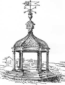
The Malt Cross
The Malt Cross was an important element of the Market Square, being the place where public announcements and punishments (whipping) were made. The Malt Cross that has been reproduced in 3D for the AR App is based on historical documentation related to an older, simpler version of the cross with a pillar on a pile of ten steps, similar to the Weekday Cross in the Lace Market (see photo n.2). After the demolition of Market Wall and the paving of the Square, a new Malt Cross was re-built as a covered cross, supported by six columns, elevated on four steps, and surmounted by six sundials and a vane, see photo n.1.
Source:
R. Thoroton, The Antiquities of Nottinghamshire, (1677), republished by John Throsby in 1797, vol 2, p.135
C. Deering, Nottingham Vetus et Nova (1751) section 1, p. 8
A. Stapleton, A catalogue of Nottinghamshire crosses, (1912), Retrieved from:
http://www.nottshistory.org.uk/monographs/stapleton1912/crosses3.htm
Photo n.2: J Potter Briscoe, The Weekday Cross at Nottingham, and its associations. Transactions of the Thoroton Society, (21) 1917. Retrieved from: http://www.nottshistory.org.uk/articles/tts/tts1917/weekdaycross/weekdaycross4.htm
Photo n.1: J. Holland Walker, An itinerary of Nottingham: The Market Place, Transactions of the Thoroton Society, 35 (1931); Retrieved from: http://www.nottshistory.org.uk/articles/tts/tts1931/itinerary1931p3.htm

The Ducking Stool
Ducking (or Cucking) Stools were instruments of public humiliation and censure both primarily for the offense of scolding or back biting and less often for sexual offences like bearing an illegitimate child or prostitution. The punished person was secured to a strong armchair fastened to a long wooden beam fixed as a seesaw on the edge of a pond. In the Market Place, the person was repeatedly poured into the cold, muddy pond used for market's livestock.
The use of this punishment machine in the Market Square is recorded in public documents and also in the old topography of an adjacent street called 'Cook Stool Row' (Cook Stool read Duck Stool). This street lined the buildings that faced the south side of the old Exchange, this was where the Ducking Stool was kept. This implement of torture was removed and more or less abandoned in 1731 consequent upon the death of a woman who had been ducked as a scold. The Ducking stool reproduced in the AR App has been modelled following one of the last original examples of this punishment tool, that is preserved in Leominster's Priory Church, and was last used in 1809.
Source:
https://www.bbc.co.uk/programmes/p08qsqwp
http://www.nottshistory.org.uk/articles/tts/tts1934/itinerary1934p1.htm http://www.nottshistory.org.uk/books/nottsrecords1915/nottsrecords07.htm http://www.davediamond.co.uk/ducking-stool.html
Image source: Pearson Scott Foresman - Archives of Pearson Scott Foresman, donated to the Wikimedia Foundation.
This file has been extracted from another file: PSF D-280003.png, Public Domain


The Research Team
The research project had been informed by an interdisciplinary research team across academic and professional practice. The team includes researchers from the School of Art and Design (Visual Arts) and Confetti Institute of Creative Technologies. Research activities are centred on Heritage (historical and archaeological analysis, historical map georeferencing), and digital Creative Technologies including 3d modelling and the creation of an Augmented Reality App.


Dr Andrea Moneta
Principal Investigator
Nottingham Trent University
Andrea is senior lecturer for Design for Stage and Screen at Nottingham Trent University, member of MoF-Museums of the Future research project within the Centre for Architecture, Urbanism and Global Heritage (CAUGH), and member of the Artistic Research Centre.
Gin Rai
Research Assistant
Confetti Institute of Creative Technologies
Gin Rai is a digital media technologist who has worked professionally in the media and games industry. He specializes in 3D modelling and digital experience design. In recent years he has been developing working practices to bridge the gap between digital technologies and both sustainability and heritage using the mediums of gaming, game development, augmented reality and virtual reality. After a short break in study after starting parenthood, he is currently working towards a series of projects in esports production alongside his doctorate that focuses on the innovative usage of emerging digital technologies in education, with context set on sustainability and heritage.
Yven Powell
Research Assistant
Confetti Institute of Creative Technologies
Yven Powell is Game Engines and Asset Production Module Course Leader at Confetti Institute of Creative Technologies. A former professional in the games industry at Sumo Digital and Codemasters, as well as being a freelancer specializing in environment art. He has now turned his time to teaching in Higher education and teachers Games Engines, Level Production and Asset Production. He has developed his skills in many areas and now focuses on texture art and creating AR applications.


